A Massive 7.6 Earthquake Rocks Papua New Guinea
On Sunday, a massive 7.6 earthquake rocks Papua New Guinea, causing landslides, cracking roads, and damaging houses. It is currently unknown how extensive the damage is; however, there is debris scattered over the highways and fissures popping up in the roads. According to the United States Geological Survey, the epicenter of the earthquake was located at a depth of 90 kilometers, or around 56 miles, and was close to the town of Kainantu, which has a population of approximately 8,500 people.
Author:Suleman ShahReviewer:Han JuSep 11, 202299 Shares1.7K Views
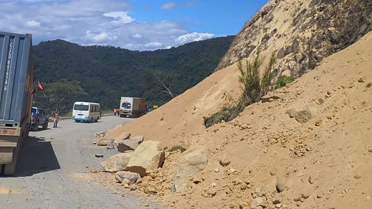
On Sunday, a massive 7.6 earthquake rocks Papua New Guinea, causing landslides, cracking roads, and damaging houses. It is currently unknown how extensive the damage is; however, there is debris scattered over the highways and fissures popping up in the roads.
According to the United States Geological Survey, the epicenter of the earthquake was located at a depth of 90 kilometers, or around 56 miles, and was close to the town of Kainantu, which has a population of approximately 8,500 people.
The National Tsunami Warning Center in the United States has reported that there is no risk of tsunami waves. It had been reported earlier in the day that potentially dangerous tsunami waves might arrive within 1,000 kilometers (about 621 miles) along the coastlines of Papua New Guinea and Indonesia.
More than sixty people were killed and five hundred more were injured when an earthquake of a comparable magnitude struck the country's remote highlands in 2018. The quake also caused landslides, destroyed homes, and caused damage to a large gas facility. As a result of its location along the "Ring of Fire" in the Pacific Ocean, Papua New Guinea is prone to earthquakes. This is because the Papua New Guinea lies alongthe Ring of Fire, which is an area where tectonic plates constantly move against each other, which results in tremors.
The boundary of the Pacific Plate, which is where the "ring" begins, is followed by a series of smaller plates, such as the Philippine Sea plate, and then finally by the Cocos and Nazca Plates, which are found along the edge of the Pacific Ocean. The entire "ring" spans a distance of 25,000 miles (40,000 kilometers). It is the location of the most active volcanoes in the world.
People who live in countries that are located along the Ring of Fire, such as Chile, Japan, the west coast of the United States, and other island nations such as the Solomon Islands to the western seaboard of North and South America, are more likely to be affected by natural disasters such as earthquakes and volcanic eruptions.
According to the officials, the tremendous earthquake has claimed the lives of at least three persons. Otherswere hurt, and there was damage to infrastructures. According to the Morobe Provincial Disaster Director Charley Masange, the landslide that killed the three people occurred in the town of Wau, which is known for its gold mining. According to Masange, who spoke to the Associated Press, there were other people who had been hurt as a result of collapsing structures or debris, and there was damage to several healthcenters, residences, rural roads, and highways.
Conclusion
According to Masange, it is possible that it may take some time before it is possible to determine the entire extent of the casualties and damage in the region. Given the magnitude of the earthquake, he speculated that the relatively low population density and the absence of substantial buildings in the region immediately surrounding the epicentre in the nation's largely underdeveloped highlands may have played a role in preventing a more severe catastrophe.
Jump to

Suleman Shah
Author
Suleman Shah is a researcher and freelance writer. As a researcher, he has worked with MNS University of Agriculture, Multan (Pakistan) and Texas A & M University (USA). He regularly writes science articles and blogs for science news website immersse.com and open access publishers OA Publishing London and Scientific Times. He loves to keep himself updated on scientific developments and convert these developments into everyday language to update the readers about the developments in the scientific era. His primary research focus is Plant sciences, and he contributed to this field by publishing his research in scientific journals and presenting his work at many Conferences.
Shah graduated from the University of Agriculture Faisalabad (Pakistan) and started his professional carrier with Jaffer Agro Services and later with the Agriculture Department of the Government of Pakistan. His research interest compelled and attracted him to proceed with his carrier in Plant sciences research. So, he started his Ph.D. in Soil Science at MNS University of Agriculture Multan (Pakistan). Later, he started working as a visiting scholar with Texas A&M University (USA).
Shah’s experience with big Open Excess publishers like Springers, Frontiers, MDPI, etc., testified to his belief in Open Access as a barrier-removing mechanism between researchers and the readers of their research. Shah believes that Open Access is revolutionizing the publication process and benefitting research in all fields.

Han Ju
Reviewer
Hello! I'm Han Ju, the heart behind World Wide Journals. My life is a unique tapestry woven from the threads of news, spirituality, and science, enriched by melodies from my guitar. Raised amidst tales of the ancient and the arcane, I developed a keen eye for the stories that truly matter. Through my work, I seek to bridge the seen with the unseen, marrying the rigor of science with the depth of spirituality.
Each article at World Wide Journals is a piece of this ongoing quest, blending analysis with personal reflection. Whether exploring quantum frontiers or strumming chords under the stars, my aim is to inspire and provoke thought, inviting you into a world where every discovery is a note in the grand symphony of existence.
Welcome aboard this journey of insight and exploration, where curiosity leads and music guides.
Latest Articles
Popular Articles